Tourist attractions of MasjedSoleyman
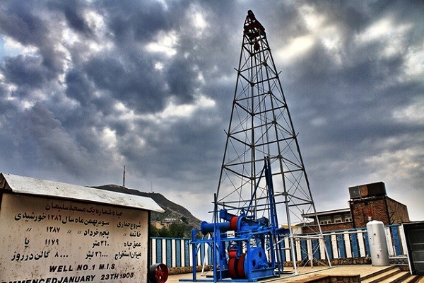
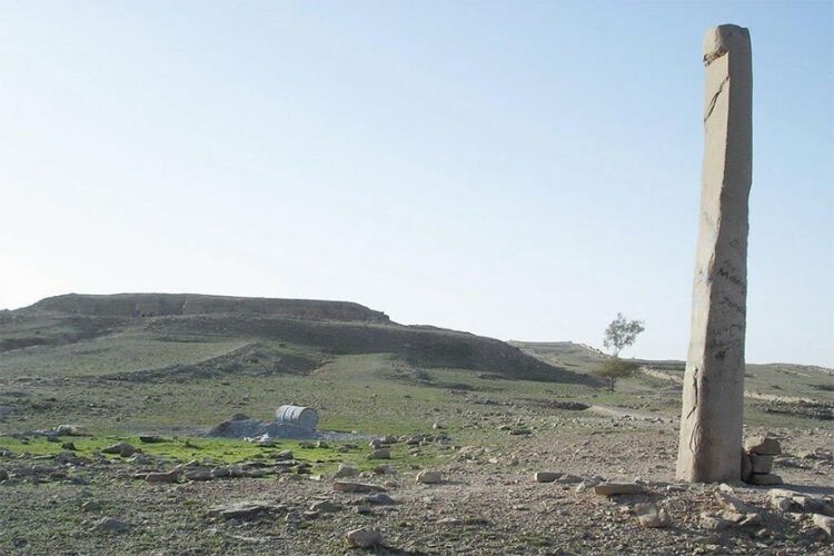
Well number one
Well No. 1 is the name of the first oil well in the Middle East, which is located in the area of MasjedSoleyman in Khuzestan province. The first oil well in the Middle East reached oil in this city in an area called Naftun field in Khorson Valley (Khorsan Valley) on June 5, 1987. The drilling of this well started in 1286 solar year and ended in 1287 solar year. This well is 360 meters (1179 feet) deep, from which 36,000 liters (equivalent to 8,000 gallons) of oil were extracted daily. The driving force of the oil extraction machines from this well was supplied by steam and was known as STEAM. This well is known as “well number one”, and it is currently located in the center of MasjedSoleyman, next to the number one area, as a museum under the supervision of the National Company of Southern Oil-bearing Regions. [۱] William Knox Darcy, (October 11, 1849 – May 1, 1917) was one of the main founders of the oil and petrochemical industries in Iran. In 1900, he signed an agreement with Henry Drummond Wolff, Antoine Ketabchi Khan and Cote for oil exploration in Iran. Their negotiations with Muzafaruddin Shah Qajar started in 1901. At first, an amount of 20,000 pounds was proposed for exploration in one million two hundred thousand square kilometers, and in case of oil discovery, this concession would be taken from Shah Qajar for a period of sixty years. In contrast, the Iranian government allocated 16% of the company’s annual profit. Of course, the British government harvested Iran’s huge oil reserves for many years after Darcy’s syndicate contract ended, and the British government received much more profit than what Darcy got.
The drilling team under the name of George Reynolds B was sent to Iran and they immediately started searching and exploring. By 1903, William Darcy had spent about 500,000 pounds, the excavation and exploration work was stopped without results. Darcy then had to make the Burma Oil Company a partner in the syndicate to get another £۱۰۰,۰۰۰٫
With the resumption of drilling work, it continued in the southern regions of Iran and in the Shardin region. In 1907, at the same time, the second point was selected and excavation began in an area called Naftun Square in the city of MasjedSoleyman. In 1908, they started digging in another place in the city of MasjedSoleyman. Excavations continued in April without any success and the final capital was running out and Darcy was completely bankrupt.
But on May 26, 1908, at a depth of 360 meters from the ground of the Naftun field, in MasjedSoleyman, the drill bit broke the last layer and the oil erupted from the ground with great pressure.

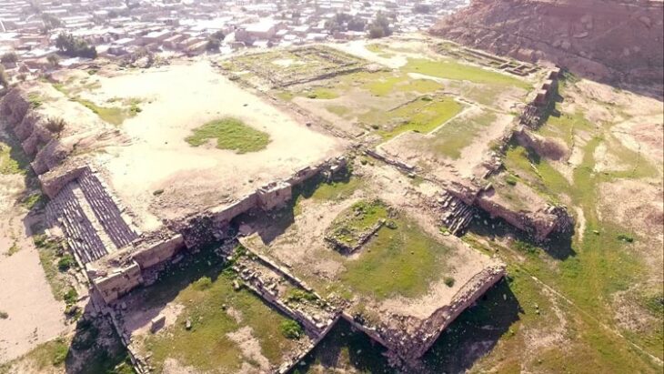
Javida fire temple (Sermasjid)
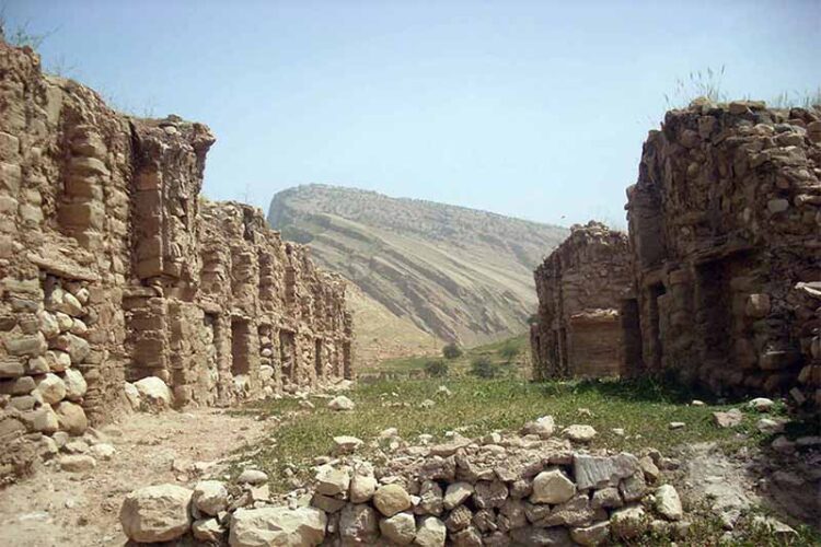
Ateshkdeh or Sarmsajd temple is one of the most important historical and ancient places of Khuzestan province, which is located in the northeast of MasjedSoleyman city. The Eternal Fire Temple (front of the mosque) located in MasjedSoleyman is a building belonging to the 7th century BC, which, according to some experts, inspired the architects to build Persepolis. The architectural type of this building is Urartu’s eternal fire temple, the most important characteristic of which is not to use mortar and to put dry stone on top of dry stone. According to the writings of professor Girshman, a French archaeologist in the book “Iran from the Beginning to Islam”, Persepolis was also built using the same model.
This temple, where a fire was always lit in the distant past, overlooks the edge of the Sarm Mosque, which, according to historians, was the seat of government of the Persians.
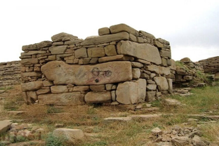
The fire temple of Sarmsajd was built by the order of one of the great Achaemenid kings and each of the large mineral stones used in it weighs 4 to 5 tons. No type of mortar was used to build the walls of this temple, and due to the frequent earthquakes in MasjedSoleyman, there is a possibility of these dry stones falling.
The altar of the fire temple belongs to the 7th-8th century BC, which includes a platform measuring 20 x 25 feet. In the eastern part of the altar, the part that is now the fire temple was built for the worship of Iranians. The western side of Iran is sacred to Greek gods, and on the western side of the fire temple, there are 3 temples dedicated to 3 ancient gods, 2 of which are Heraclius and Athena.
A 25-meter-wide staircase led the believers to the side near the holy place, and since at the end of the prayer ceremony they should not return by the same way they came, another staircase was built in the other corner of the eastern side to go down. According to Professor Girshman, the history of the establishment of one of the Persian tribes in MasjedSoleyman dates back to the end of the 8th century BC. Pottery vessels, old coins, ancient statues and ancient works have been obtained from this historical building, which are kept in internal and external museums. Every year, tourists from all over Iran and even abroad travel to Khuzestan province to visit this valuable ancient work. Sarmsajd fire temple was registered in the list of national historical and ancient monuments of the country in 1316 with number 300.
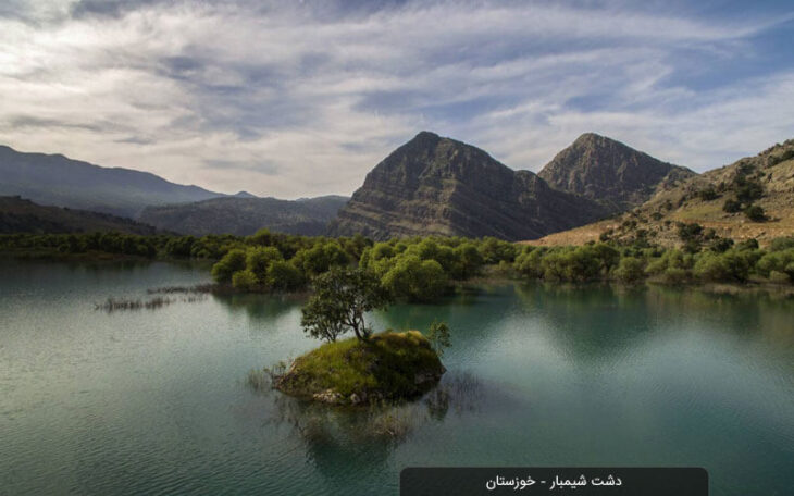
Golgir plain
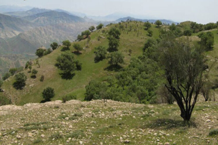
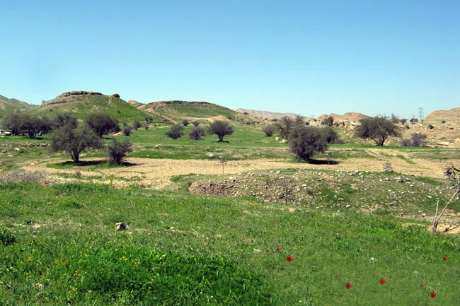
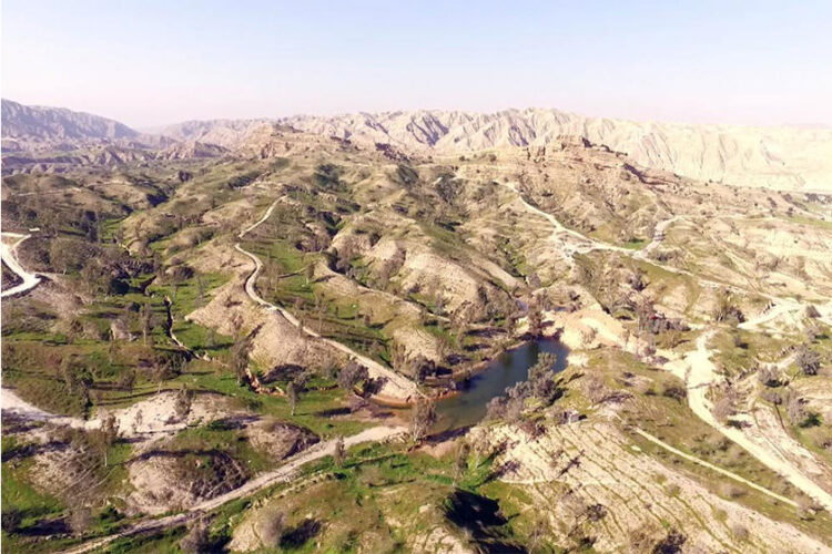
One of the most beautiful regions of Iran, 38 kilometers northeast of MasjedSoleyman, is a beautiful region called Gol Gir. According to the name of this area, it is a plain full of flowers, greenery, and beauty. It has a high potential in terms of attracting tourists and can overtake many areas. Golger has a spring of sulphurous water, which spontaneously boils from the depths of the earth. The spring water is hot in winter and autumn and cool in summer and spring. In terms of having sulfur in the water of this spring, it has many therapeutic properties and can treat joint pains.
No hunting zone and Lander
No hunting zone and Lander in MasjedSoleyman, which is located in South Zagros, which the diversity of flora and fauna and ecological conditions of this area has made it one of the valuable areas of the province and the country in terms of wildlife and high habitat capabilities. This area is one of the habitat areas of the emperor salamander, one of the beautiful and globally important species. Lorestan salamander or emperor salamander with the scientific name Neurergus Kaiseri is one of the seven salamander species known in Iran. This animal is known by the names of orange salamander, Caesari salamander, emperor salamander and mountain salamander of Lorestan, its local names are Haji barik ab, colored lizard, and wafqi. The body is red-orange in color and the dorsal surface has a shiny black background and orange spots along with white spots and black and white spot-like spots on the tail and legs mixed with orange color. In terms of global distribution, this species is native to Iran and is distributed in southern Lorestan and parts of northern Khuzestan, but the remaining habitats of this salamander are limited. The emperor salamander is on the IUCN Red List (on the verge of CR extinction) and will become extinct in the wild in the near future with this population decline. The Convention on the Prohibition of Trade in Endangered Species of Plants and Animals has prohibited the sale and purchase of this species in Iran and other countries of the world since 2010. The Hunting Prohibited Zone and Lander in MasjedSoleyman, which is located in South Zagros, because Plant, animal diversity and ecological conditions have made this region one of the valuable regions of the province and the country in terms of wildlife and high habitat capabilities. These three areas are among the areas that, based on the resolutions No. 334 and 346 of the Government’s Infrastructure Affairs Commission, based on paragraph (f) of Article 6 of the Environmental Protection and Improvement Law, are protected areas of “Chelpa” and “Mishdagh” and “Hunting Area”. They are known as “Forbidden Show and Lander”. With the increase of these areas, the level of protected areas of the province, which was 6.8% in 2003, reached 10.8%, which is beyond the international standards.

Shimbar plain
Shimbar plain or Shirin Bahar is the border of Khuzestan and Chaharmahal and Bakhtiari provinces, which is located 75 kilometers from MasjedSoleyman and is one of the most attractive recreational spots of this city with ten thousand scattered rural and nomadic population. One of the sights of the Shimbar plain is Qalandaran mountain, which was a refuge for rebels and opponents of the governments of the time. The plain is full of ruby grapes that have no private owner.
This area is located on the slopes of Dela Mountain on one side, and its range starts from Sarhuni and divides Shirin Bahar into two parts, upper and lower. Shirin Bahar includes the following areas: Tang Sano (Tang Senan), Negin Bridge, Passage, Imamzadeh Saleh Ebrahim. The existence of many springs and beautiful waterfalls, as well as the existence of a river known as Shat Shimbar next to the forest covered with all kinds of oak trees, almonds, wild plants such as mushrooms, and all kinds of citrus fruits, mountain grapes, berries, pomegranates and apples, a special beauty for this is the data area. The existence of soaring mountains suitable for climbing and covered with various flowers and bushes and all kinds of animals has doubled the beauty of the region. Due to the presence of suitable soil and favorable climate, agricultural products such as wheat, barley, peas and lentils are planted in this region.
In terms of historical works, we can mention the reliefs of Teng Beta and Teng Senan. These petroglyphs are carved on the breast of the mountain, which by considering the type of covering and hairstyle of these petroglyphs can be said to be at the same time as the Parthian period and related to the Elimaids (the local government at the same time as the Parthians, and Indica is a part of their territory are considered)
Seyyed Mohammad Ali Shushtri in the history of geography of Khuzestan writes about Teng Beta as follows: “In Teng Beta, twelve human figures can be seen in two designed assemblies, the figures on the right consist of three people with a shorter stature than the rest of the people, while whose left hand rests on the shoulder of the person next to him. The other people are also seen in the same way. Two people wear crown-like crowns that distinguish them from the other people. It seems that they are the queen and the king’s wife. The other people may also be They are courtiers and they all wear uniforms like Chinese Parthians, so it is understood that they are all performing religious ceremonies.
Varieties of Burdguri (Studan): Iranians of ancient times believed in the sanctity of the soil, which is one of the four elements of creation, and considered it necessary to be clean, so they strictly avoided the contact of the bodies of the dead with the soil. They put them in the open air so that their meat becomes a prey for animals and birds, and after a while when only the dead bones remain, they put them in the studs, these studs are in the heart of the mountain or in the heart of the rocks that are separately in different places. They were scattered and dug up. Of course, there is another opinion about bardgori and that is: during the migration, old people who were not able to accompany the nomads were placed inside these bardgori along with enough water and food. There is an old Bakhtiari, and not even those who express this matter have seen it with their own eyes and only refer to what they have heard. Considering the compassion and kindness and respect for the elders, especially the elderly, in the eyes of the Bakhtiaris, as well as the impossibility of observing health issues in such conditions, this theory seems far from reality.
Another work of Shirin Bahar is Pol Negin or Khoda Afrid. This bridge transfers fresh spring water to the Karun River
and its history dates back to the Parthian era. Other works can be mentioned: Imamzadeh Saleh Ibrahim, ancient hills and reliefs and stone lions. In addition to the mentioned items, there are also old aqueducts in this area. Qobad Bagheri in Bakhtiari’s book in the passage of time, quoting local people, states that there are castles called Kaleh Qandi Castle, Ahangari Castle, and Dzuraz Castle (Dermena) on top of Mount Dela and in the southwest of these reliefs. These castles may once have been the rule of the Elymaids. Layard considers this role of the searchers to belong to the Sasanian era.
Shirin Bahar’s handicrafts can be mentioned from Galim Baghi, carpet weaving, Lat (black tent), making musk and sewing local clothes and Lakh.
Among the ceremonies that are considered as a part of the Bakhtiari people’s identity, we can mention mourning ceremonies and happy celebrations. The local games of this area include: Chukli game, alkhatar, horse riding, shooting, which are played by children and adults on different occasions. The population of this area is variable. In all seasons of the year, you can see the beautiful scenery of Shirin Bahar. Among the traditional dishes of this region, we can mention Bakhtiari kebab, Otarshi, Obsur, fried shallots and mushrooms, Garde and Tocheri. The souvenirs of the village include citrus fruits, honey, mushrooms, oil and local bread (Nun Thiri), local butter, curds and kara, etc.
Shirin Bahar has a very beautiful, pristine and rare nature that is unique in its kind. With the combination of natural scenery, historical monuments and ethnic culture, this area has the potential to become a tourist destination.
Source: Bakhtiari in the passage of time – Qabad Bagheri
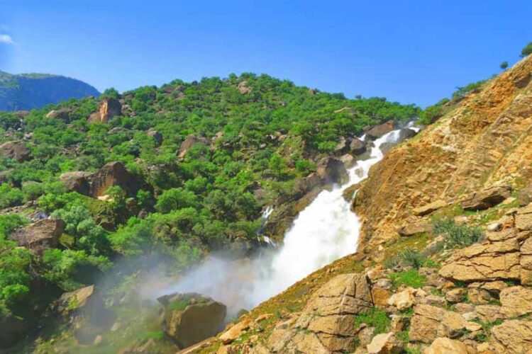
Negin waterfall
Nagin MasjedSoleyman waterfall is located in Khuzestan province. Negin waterfall is located in a village with the same name in a very deserted and remote place among the mountains and plains of Shimbar region, north of Shahid Abbaspur dam lake. The best way to visit this path and its waterfall is the path that leads from MasjedSoleyman to the village of Ab Shalal and from there it takes about four hours of hiking to reach the pristine and untouched village of Negin and its beautiful waterfall. Of course, this area can be accessed from Shahrekord, Junqan, Behesht Abad and after passing through the passes of Mount Milli and Chaman Goli Miz, which is more suitable for hiking. At the top of this high and slide-like waterfall, there is an opening that directs the water to the other side of the mountain and creates a waterfall that really shines like a jewel across the expanse of this pristine and untouched land. Downstream of the waterfall is the beautiful plain of Nagin, which leads to the shores of Shahid Abbaspur Dam lake. Very beautiful and dreamy landscapes with plains full of anemones on the slopes covered with oak trees and magnificent and rocky walls and most importantly, deep and exciting valleys have added to the beauty of this region. This beautiful area is located one hundred kilometers northeast of MasjedSoleyman and bordering Khuzestan, Chaharmahal and Bakhtiari provinces.
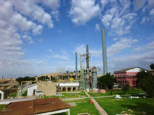
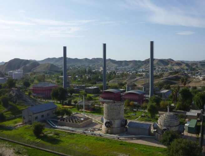
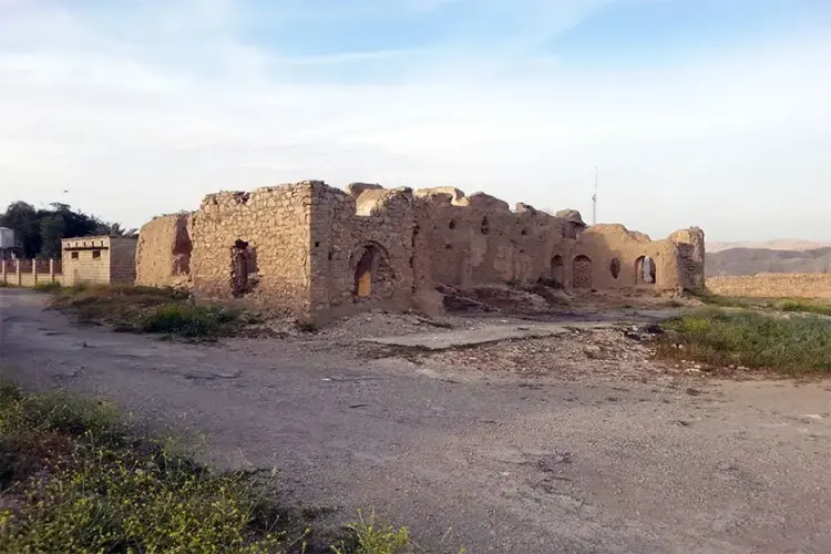
Bay Bayan Refinery
Bibiyan Refinery was established about 80 years ago, four kilometers from MasjedSoleyman, and it was operated until 1352.
Berdanshande Temple
Berdanshande Temple belongs to the Achaemenid period and is located in Berdanshande, 16 km from MasjedSoleyman, Shahid Abbaspur Dam Road. This work was registered as one of Iran’s national works on March 2, 1327 with registration number 372.
Berdshande is the oldest Iranian open-air place of worship and dates back to the Achaemenid period, where religious rituals were performed in the open air for centuries. It is about 700 meters long and 2500 meters wide.
This wide and long complex includes three parts: the palace where the chief resides, the prayer hall (in the east of the palace) and a town in the north.
Its building belongs to the Persian and Achaemenid periods, and the reliefs on it date back to the Parthian era. Several objects found during the excavation show that the main foundation was built in the Achaemenid period. Therefore, this is the most ancient place of worship of ancient Iranian religion.
The ancient hill of Kalga Zarri (Zarin)
The ancient hill of Kalge Zari is located in the south of the city of MasjedSoleyman, in the area of Kalge and is related to the third millennium BC. The carved works of the revolution of Prophet Ibrahim (AS) on a rock in the Golden Calf of Iran, located in the current MasjedSoleyman, have shown the acceptance of this religion by the people. Some Iranian and German archaeologists have obtained it as a result of exploration around 1355. The length of this inscription is 6 meters and its width is 4 meters, which is engraved on a huge rock and the description of the inscription is as follows: “A mother with a long skirt, the end of her skirt is held by two other women, while a child is on her hands. He has placed himself, he leads to the altar. From above and in front of him and from the side of the sky, a large eagle with open wings has taken a ram in its claws and has appeared in the distance between the mother and the altar. This building is the first and oldest work of the Abrahamic revolution in old Iran.
Artifacts from the Sassanid and Parthian periods have been found in this place, and it was also important in the Achaemenid era. They say that the Achaemenid financial center and bank was in this place and the surrounding hills.
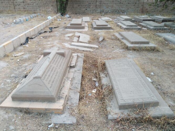
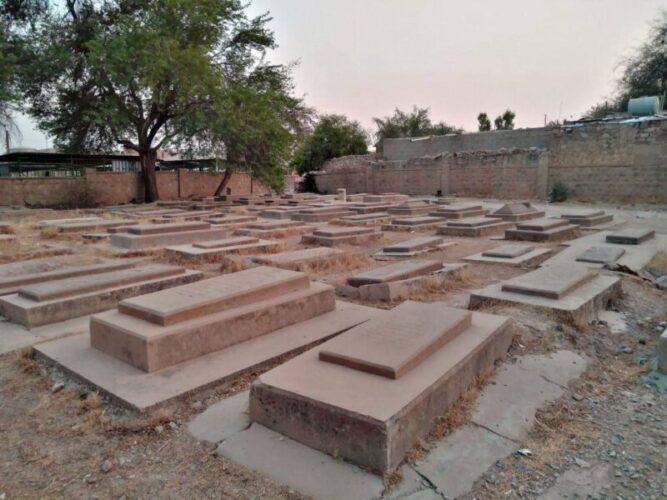
Armenian cemetery
With the successful drilling of the first oil well in the Middle East in MasjedSoleyman, the flood of migration of various ethnic groups in search of work to this city begins, and the Armenians also form a small organization in the community of seventy-two nations of MasjedSoleyman, and this small cemetery is a reminder of the presence of people who have been there for a long time. They have moved from this city. The history of this place, which is located in Naftun neighborhood and next to Gulzar Shahada, dates back to the last 100 years (oil exploration era) and is the burial place of Armenians who came to this area from different places to work. Some of the tombstones in the cemetery are granite, and some of them have the sign of the cross, violin, etc. . . The role is closed.
The historical city of Banewar
Banevar historical mansion is related to Khanin Ayl Zalqi and is located in MasjedSoleyman city, Banevar village and this work was registered as one of the national works of Iran on 23rd of Shahrivar 1382 with registration number 9964. From the lineage of Tajmir Khan Bakhtiari and Mirjahangir Khan Bakhtiari, the works and historical buildings of Moazzami have been left in different parts of Bakhtiari, including the ruins of Sardasht near Dezful and Bonewar in Garmsir region, as well as in Dimeh and Chagha Khor in Sardsir. The historical works and remains of this dynasty in the tropical parts of Bakhtiari have been a clear proof of their glory. It was very big and vast because in this place, in addition to the ruler and chief, other chiefs and sheriffs and elders of the clan near the seat of Hakmravai Khan had numerous buildings and houses, and even now some of those works that are more related to the main palace It is obvious that the Khan was big, and its different parts such as the kitchen, the office, the bed and the big bathrooms (the proof of their civilization) are evident.
The blessed shrine of Imamzadeh Haft Shahidan
Haft Shahidan village with an area of about 9402 hectares, in the central part of MasjedSoleyman city, Jahangiri district, has a population of 395 people and 69 households. This village is located near MasjedSoleyman city and Lali city in Khuzestan province. The people of this area are from Bakhtiari tribe. Access roads to the Haft Shahidan area include: MasjedSoleyman-Ahwaz asphalt road, MasjedSoleyman-Lali asphalt road, Sultanabad village sand road, Qiblai sand road, Prince Abdullah sand road and Shamsabad. Imamzadeh located in Haft Shahidan village, related to; It is Sadat Talghar, who were seven people and related to Sayyid Abdullah bin Musa Kazem. These 7 people included five men and two women. The place of this imamzadeh is located in the middle of Haft Shahidan village cemetery.
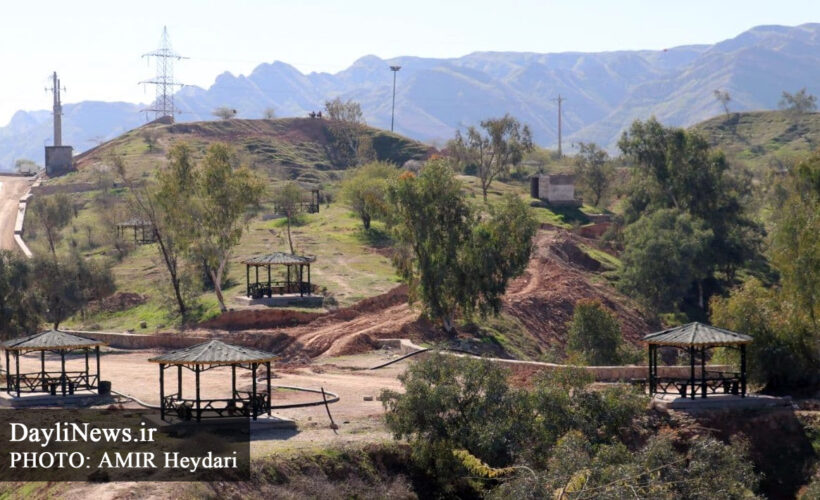
Hill of unknown martyrs
The Unknown Martyrs recreational cultural complex, which is considered one of the major projects of the MasjedSoleyman municipality, is a place with a spectacular view and unique furniture, and has a children’s park, beautiful pavilions and terraced green space in Kanal Al-Man, commemorating the 13-year-old martyr of the MasjedSoleyman, Behnam Mohammadi. It can be a good pastime for guests and tourists.
Cham mill
Dasht Cham Asiyab is located 5 kilometers away from the city of MasjedSoleyman and on the road of Indika. Cham Asiyab welcomes many guests from all over the province due to its many springs and gardens in the spring season.
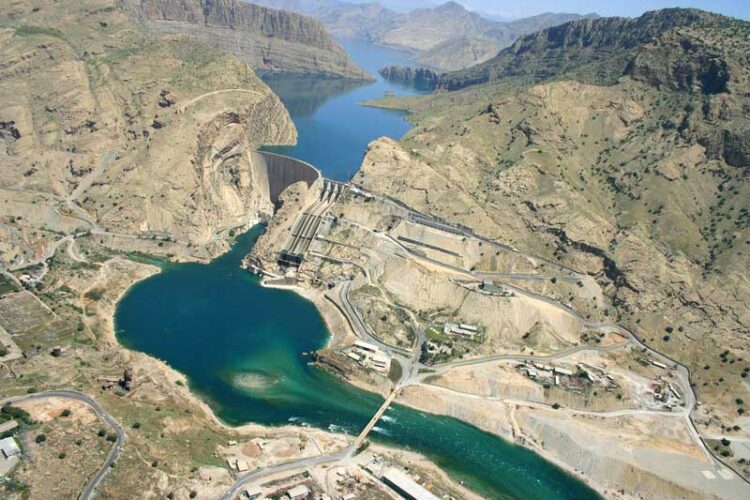
Shahid Abbaspur dam
Shahid Abbaspur Dam or Karun 1 Dam is one of the largest dams in Iran, which was built on the Karun River in the south-west of Iran. This dam is located in Khuzestan province and 50 kilometers northeast of Masjid Sulaiman city. Karon 1 Dam is a double arched concrete. The height of the crest of the dam is 188 meters and its crest length is 385 meters. This dam is one of the first dams built in Iran and the Middle East, the construction of its body started in 1344 and continued until 1354.
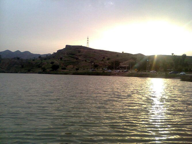
Tembi Recreational Dam
Tembi recreational dam with a beautiful view, which is located next to Tembi bazaar power plant, and with a spectacular view, it is a beautiful place for tourists and local people of MasjedSoleyman, so that on holidays, a large number of citizens can be seen in this area for a rest. For several hours, he observed that they have hit the heart of nature. This beautiful recreational area is located 5 km south of MasjedSoleyman, next to Tembi Bazaar.
Tembi Forest Park
Tembi Forest Park, which is located next to the recreational dam of this area, is a very beautiful place with a natural and beautiful view, along with the pavilions built in this area, it is a memorable place for sightseeing. This area is located 6 kilometers south of MasjedSoleyman, next to the Tembi power plant.
ارسال دیدگاه